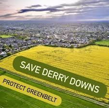
Please help save St Mary Cray Green Belt

Green Belt land at St Mary Cray / Derry Downs in Bromley is under threat from housing development, but:
- We do not need to build on Green Belt. There is widespread brownfield land in London and planning permission in place for 300,000 homes which are simply not being built. We have a huge supply of previously developed (‘brownfield’) land and planning consents in London.
- We have written elsewhere about why building on Green Belt will not solve the housing crisis.
We do not believe landowners and developers should be able to cash-in on countryside they bought years ago cheaply, just because available brownfield land is too expensive for them to be able to make a profit.
Please consider submitting an objection. This is strategically important for the whole of London. Our Green Belt matters! It stops damaging, car-dependent sprawl, and delivers ecosystem services like rainwater and air temperature management, as well as local food growing and areas for recreation.
Notes for objectors. Here are two different responses you could consider. These have been sent to us by local campaigners.
1. “I object to this planning application. The proposal represents inappropriate development in the Green Belt, fails to address the significant pressure on local infrastructure, and promotes an unsustainable and car-dependent form of growth that is inconsistent with national, regional, and local planning policy.
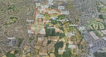
The site is designated Green Belt, and development of this nature is considered inappropriate unless very special circumstances can be demonstrated. No such circumstances have been established. Bromley officers have previously stated that the development is “unacceptable in principle” due to Green Belt harm and site constraints. The construction of up to 350 dwellings, with associated roads, lighting, parking, and infrastructure, would result in a major and permanent loss of openness. The applicant’s reliance on classifying the site as “Grey Belt” is disputed by the Local Authority, who confirm that the land makes a strong contribution to Green Belt Purpose A (preventing unrestricted sprawl) due to its open and undeveloped nature. Independent assessments similarly identify that the development would lead to a major loss of openness. The site also comprises undeveloped agricultural land with a high likelihood of being Best and Most Versatile, and its loss has not been justified in accordance with Local Plan Policy 62.
The application does not provide adequate mitigation for the significant pressure the development would place on local infrastructure. Local GP surgeries are already operating at or near full capacity, and while community or healthcare floorspace is proposed, there is no guarantee this would result in new NHS-commissioned provision. Concerns have also been raised regarding school capacity, and no firm, deliverable mitigation has been presented. The site is subject to significant surface water flood risk, and there is a documented history of flooding on the land itself. Mapping indicates potential water depths of up to 900mm and hazardous flow velocities above 0.25 m/s. Given this known flood behaviour, the drainage strategy remains insufficiently detailed to demonstrate that flood risk can be effectively managed.
The location of the site is unsustainable. It has a Public Transport Accessibility Level (PTAL) of 1a, the lowest possible rating. Bromley’s planning officers conclude that the site is not a sustainable location and that future residents would be heavily reliant on the private car. The applicant’s reliance on a possible rerouting of a bus service, such as the R4, is uncertain and cannot be relied upon at this stage, as TfL has explicitly stated there is no guarantee it would be viable or deliverable following consultation. Residents already experience congestion on Kent Road, and narrow surrounding lanes, such as Cockmannings Road, are unsuitable for additional traffic. The proposal’s reliance on pedestrian routes through St Mary Cray Recreation Ground also raises concerns, as TfL has noted that these routes are unlikely to feel safe at all times of day and that parts of the network lack adequate lighting.
The proposed parking ratio of 1.5 spaces per dwelling has been criticised by the GLA as too high and risks embedding long-term car dependency. This level of provision is likely to create a car-dominated environment that conflicts with policy objectives to reduce vehicle reliance. More broadly, introducing 350 homes onto what is currently open rural land would be incongruous and would significantly alter the character of the area, eroding the rural edge of St Mary Cray and undermining its landscape setting.
In summary, the proposal would cause clear and demonstrable harm to the Green Belt and its openness, to local infrastructure, to the sustainability of local transport, and to the existing character of the area. These harms significantly outweigh the claimed benefits. I therefore respectfully request that the application be refused.
2. Local residents are right to be concerned about the proposal for 900 homes south of Crockenhill Road, and the more you read through the documents, the clearer the weaknesses become. One of the biggest issues is that the developer relies heavily on the new “grey belt” policy in the updated national planning framework, but the Planning Statement never actually shows that this land qualifies. To be classed as grey belt, the land must be previously developed or make only a weak contribution to the purposes of the Green Belt. This land is open countryside, used for farming, forming a clear and long-standing buffer between communities. Bromley Council’s own pre-application advice, which the developer included in their document, even says that none of the usual exceptions for inappropriate development in the Green Belt apply here. The developer quotes the grey-belt rules but doesn’t provide the evidence needed to prove that this particular site meets them.
There is also the issue of agricultural quality. The Planning Statement acknowledges a high likelihood that the land is “Best and Most Versatile” farmland. National policy protects high-quality agricultural land unless there is no realistic alternative. Here, the developer doesn’t demonstrate that the loss of productive farmland is unavoidable, nor do they show why development has to be placed on this greenfield site rather than on poorer-quality land elsewhere in the borough. Without that evidence, this remains a major policy conflict.
Transport and sustainability are another major weakness. The site has the lowest possible rating for public transport accessibility: PTAL 1a. This is the rating for locations with almost no usable public transport. In the developer’s own Planning Statement, Transport for London express serious concerns about whether a site this poorly connected could ever support a development of this size. There are no firm commitments to improve bus services, no confirmed upgrades, and no guaranteed funding. Bromley Council also warns that most residents would still rely on cars, even with new walking and cycling routes, which goes against national policy requiring major developments to be genuinely sustainable. When both TfL and the Council say the location simply isn’t sustainable, that’s a significant weakness.
The question of infrastructure delivery raises further concerns. Bromley Council’s comments within the Planning Statement state that if the required infrastructure cannot be delivered, the scale of the development “should be reconsidered.” This is a clear sign that the Council already has doubts about whether roads, schools, GP provision, utilities, and drainage can cope with such a large additional population. The developer has not provided concrete phasing plans or delivery commitments for these essential services. Without that, the proposal risks being considered undeliverable at the size proposed.
Ecology is another area where problems emerge. The site borders important ecological areas, including Kynaston Wood and protected woodland. The Council’s feedback in the document makes clear that any development affecting a Site of Importance for Nature Conservation must only proceed if the benefits outweigh the harm. The Planning Statement does not go into detailed ecological mitigation, and while the developer has uploaded separate surveys and biodiversity documents, the main statement doesn’t demonstrate how potential harm to habitats, species, or woodland edges will be prevented. Residents will need to look carefully at the ecology documents to see whether these crucial issues have been properly addressed.
The same applies to Biodiversity Net Gain. The Planning Statement explains the strict national requirements but doesn’t itself include the necessary calculations or habitat value information. These may be located in the separate ecology files, but from the Planning Statement alone it isn’t possible to tell whether the proposal actually meets the required gains or how they will be delivered. Until that is clear, this remains an area of uncertainty and potential weakness.
There are also practical issues with the design. One example is that the proposed internal road layout does not align with Rookesley Road, even though this would be the most natural and direct connection. Bromley Council’s comments question this decision, suggesting the layout hasn’t been properly planned around existing movement patterns. Poor integration like this risks pushing more traffic onto unsuitable roads and undermines the claim that the development will support walking and cycling.
Finally, the developer claims the scheme is needed to meet housing pressure, but they have not shown why this particular greenfield site must be used. They have not demonstrated that alternatives—such as brownfield regeneration, smaller urban extensions, or sustainably located sites—cannot meet the need. Without a clear and specific justification for why 900 homes must go here, the argument for overriding Green Belt protection remains weak.
Overall, when you look closely at the developer’s own Planning Statement, it paints a picture of a proposal that doesn’t meet key policy tests. The evidence suggests it is in the wrong place, in an unsustainable location, on protected farmland, next to sensitive habitats, and without firm infrastructure commitments. Residents have every reason to oppose it, and these weaknesses give a strong and defensible basis for doing so.