20 July 2023 – London’s Lost Woodlands
By Dan Schofield, CPRE Volunteer.
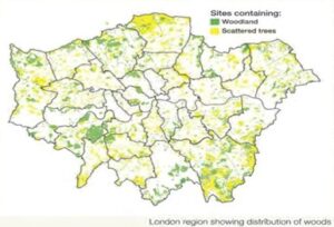
Tree coverage in London amounts to 21% of London, so why are the areas of woodland so scattered?
We’ve previously explored the history of the Royal Forest of Waltham, this time let’s look at some of London’s other lost woodlands. London’s Woodlands cover about 4.5% of the region and about 40% of them are ancient.
The woodland of the London area has been managed from the Bronze Age. With the growth of London in the Middle Ages (12th-15th centuries) fringe woodland, such as at Highgate, Leyton, Dulwich, and Wimbledon, were managed to support many of London’s trades and industries. These included:
- Charcoal burning of hornbeam and oak. The charcoal was used for fuel for cookhouses and metal working (The National Coppice Federation reported figures from the International Trade Centre, showing the UK imported over 98,000 tons of charcoal in 2020)
- Tanning-using oak bark needed for making leather, based in Bermondsey.
- Ship building: Sir Francis Drake’s ship the Golden Hind was made from oak timber from Great Stake Pit Coppice near Norwood.
- Building construction, including the wharves of Roman and medieval City of London.
- Many woods had the job of supplying firewood to the growing city of London. In the eighteenth century this declined through increased competition from coal.
Woodlands, along with commons and heaths, were privately owned, although “rights of common” have their origin in local custom which date back to the medieval period or earlier. Commoners rights were attached to particular properties and could include, for example, the right for pigs to forage on beechmast and acorns (pannage), to remove peat for the hearth (turbary), to fish (piscary) and to collect bracken or firewood (estovers).
Commons provided an important economic role as places for grazing livestock and as a crucial source of fuel. The extent of commonland in London has been reduced by enclosure and development. Most commons used to be grazed but since this ceased many have developed into scrub and woodland. However, in some cases old, open grown trees survive. Many commons were managed as wood pasture with grazing animals kept beneath an open canopy of pollarded trees.
Forest of Middlesex
Covering much of the county of Middlesex that was north of the City of London, it now forms the northern part of Greater London. At its ancient extent the forest stretched twelve miles north from the city walls at Houndsditch. The boundaries of the Forest are not clear, but Domesday returns for Middlesex as a whole indicate that it was around 30% wooded in 1086. It also records that the forest provided autumn feeding for a vast herd of upwards of 20,000 pigs!
A part of it called Tottenham Wood survived for many centuries. Nearby Seven Sisters is named after seven elms encircling a famous walnut tree. The London neighbourhood of St John’s Wood reflects that part of the forest later owned by the Order of St. John of Jerusalem. Remaining fragments of the ancient forest include Harrow Weald Common, Highgate Wood, Queen’s Wood,
Perivale Wood, North Wood in Kenwood, and Scratchwood.
Highgate Wood is oak and hornbeam coppiced woodland. Prehistoric flints have been found in the wood. During the Medieval Period, the wood was part of the Bishop of London’s hunting estate. It is possible that an ancient earthwork that runs across the wood formed part of an enclosure for deer or it may be from an earlier period. Roman pottery kilns AD 50-150 have been found here.
Enfield chase
British History Online states “It was at Enfield, bordering on the Essex forest of Waltham, that the woodland of Middlesex chiefly prevailed for several centuries”. The first record of Enfield Chase is from the 11th Century. The woodland extended about 8½ miles from east to west, and from 3¼ to 6 miles in width.
The largest oak then standing on the chase was felled in 1766, measured 30 ft. long and contained about three tons of timber. The price was £10, the equivalent of around £950 in 2017.
Today, Thames21 is working in partnership with Enfield Council to restore 60 hectares of Enfield Chase in what is currently London’s largest reforestation project.
Oxleas woodlands
This woodland dates back to at least the 12th century, and their management is known from the mid-14th century. In 1311, the Royal manor of Eltham was established and included the woods. The woods passed out of Crown occupation in 1679 and were eventually acquired in 1934 by the London County Council and opened to the public.
Remnants include, Oxleas, Jack and Shepherdleas Woods, Castle Wood (home to Severndroog Castle), Oxleas Meadows, Falconwood Field, Eltham Common and Eltham Park North.
Burnham Beeches
Burnham Beeches have been described as one of the finest surviving woodland tracts anywhere in Britain. The Burnham Beeches are the remnants of a vast forest that once covered almost the entire county of Buckinghamshire. Woodland has been in this area probably since the end of the last ice age, as a part of the Wildwood which covered much of Greater London. It is owned and managed by the Corporation of London who, in 1880, bought the woodland to save it from prospective developers.
Royal Liberty of Havering
Parkland and forest surrounded Havering Palace and covered most of the Parish of Havering-atte-bower. Havering Palace had frequent royal visitors including William the Conqueror through to Charles I including Catherine of Aragon, Ann Boleyn and Jane Seymour while they were Queens. There is also evidence of Roman remains in the area. A cache of coins found suggests the existence of a Roman villa.
The woodland was a much more extensive area than the current 100 acres of woodland Havering Country Park covers today, probably forming a continuous tree canopy with the Forest of Waltham to the West. The current country park was created when plots held by East-enders (many of whom had started to live permanently in the forest, and begun to build bungalows) were compulsory purchased by the Greater London Council in 1970.
The Woodland Trust has opened Sandhills Wood in this area in a reforestation project.
Pirgo Palace woodland
Pirgo Palace was next to Havering Palace and was a Royal residence for Henry VIII. A park was constructed in 1537, covering 200 acres of open land and 100 acres of woodland. Today, a much smaller Pyrgo Park, despite being within the boundaries of Greater London is owned and managed by Essex County Council, a hangover from the 1965 local government boundary change.
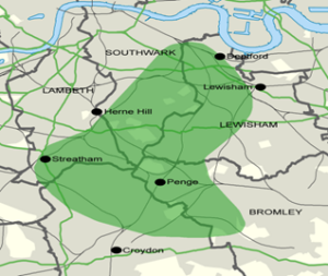
Great North Wood
This forest used to stretch for several miles between the Thames and Croydon, between Camberwell, Deptford to Selhurst and Beckingham. The first mention of this woodland is from 1272 when it is recorded as measuring 830 acres, although like Burnham Beeches, it is likely there was woodland in this area from the last ice age, from the Wildwood. It is where the place name ‘Norwood’ comes from.
Private landowners cleared much of the woodland under the Croydon Inclosure Act 1797. Twenty small fragments or re-plantations remain including Dulwich Wood, Sydenham Hill Wood, Biggin Wood, Beaulieu Heights. The London Wildlife Trust has a Great North Wood project to increase awareness and restore the fragments of Great North Wood which began in 2017.
Can you help?
Do you know of anywhere in and around London that would be perfect for new woodland or tree planting? Let us know! CPRE London have teamed up with GiGL to create a survey to identify priority sites for woodland creation as part of CPRE London’s campaign for creating ‘The Tree Ring’ – a continuous ring of woodland around the capital.
Please complete the survey below with any potential sites you know of: https://survey123.arcgis.com/share/0284c55ac02c403480fa2a79073d97d1
Credits
Woodland archeology in London,
John K. Morris, Director of the Chiltem Woodlands Project ltd
British History Online – https://www.british-history.ac.uk/vch/middx/vol2/pp223-251#h2-0001
The (almost) vanished great Forest of Middlesex – https://www.bitesizedbritain.co.uk/the-vanished-great-forest-of-middlesex111/
London Wildlife Trust, Great North Wood – https://www.wildlondon.org.uk/greatnorthwood
History of Havering Country Park- https://www.havering.gov.uk/info/20037/parks/723/havering_country_park
Discover the Great North Wood – south London’s forgotten landscape – http://love.lambeth.gov.uk/great-north-wood-planting-session/
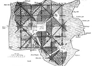
Map from Hugh Westlake’s survey of Enfield Chase 1700 – https://pasttenseblog.wordpress.com/2016/07/09/today-in-london-rebel-history-poachers-battle-game%C2%ADkeepers-enfield-chase-1725/comment-page-1/
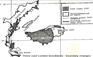
Map from Three East London Woodlands: A potted History and Ecology, Denis j Vickers 1988 – https://www.consultantecologist.co.uk/threeeastlondonwoodlands.htm
National Coppice federation UK Charcoal information- https://ncfed.org.uk/public/products/charcoal/